
Search
Search Results
Image
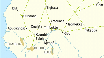
Trans-Saharan Trade Routes
A map indicating the major trans-Saharan trade routes across West Africa c. 1100-1500 CE. The darker yellow areas indicate gold fields.
Image
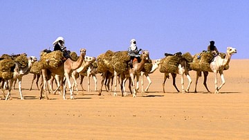
Trans-Saharan Camel Caravan
A trans-Saharan camel caravan carrying salt. Agadez to Bilma, Niger.
Article
The Roman Empire in West Africa
At its fullest extent, the Roman Empire stretched from around modern-day Aswan, Egypt at its southernmost point to Great Britain in the north but the influence of the Roman Empire went far beyond even the borders of its provinces as a result...
Article
Partnership with Mohawk Games
We are pleased to announce that we have entered into a partnership with Mohawk Games a games company that shares our goal of engaging people with ancient history. Mohawk Games has just published Old World, a historical strategy game about...
Image
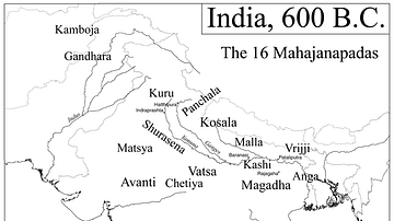
Map of India, 600 BCE
Mahajanapadas (Sanskrit: महाजनपद, Mahājanapadas), literally "great realms", (from maha, "great", and janapada "foothold of a tribe", "country") were ancient Indian kingdoms or countries. Ancient Buddhist texts like Anguttara Nikaya make...

Image
Western Sahara, Catalan Atlas
A map of West Africa from the 1375 CE Catalan Atlas. The map shows the trans-Saharan caravan trade routes between North Africa and the Niger River. (Sheet 6, National Library of France, Paris)
Image
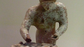
Terracotta Figurine of a Baking Woman
Terracotta figurine of a woman kneading pieces of bread or pancake, c. 500-475 BCE. National Archaeological Museum, Athens. This clay statuette shows a woman baking bread as one of her daily chores. That she is less likely to be an...
Image Gallery
10 Maps on European History
In this gallery of 10 maps on European history, we explore the dynamic borders and the fragile quest for peace on the continent. Witness the shifting borders and the persistent efforts of nations to achieve stability amidst the ever-changing...
Video
Old Towns of Djenné (UNESCO/NHK)
Inhabited since 250 B.C., Djenné in Mali became a market centre and an important link in the trans-Saharan gold trade. In the 15th and 16th centuries, it was one of the centres for the propagation of Islam. Its traditional houses, of which...
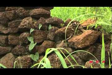
Video
Ruins of Loropéni (UNESCO/NHK)
The 11,130m2 property in Burkina Faso, the first to be inscribed in the country, with its imposing stone walls is the best preserved of ten fortresses in the Lobi area and is part of a larger group of 100 stone enclosures that bear testimony...